Monday, November 25, 2019

Back To Mohawk


Back again


We headed back up to Mohawk for another hike along the Deerfield River.  We wanted to wander down the trail called Elders Grove, which according to the map stopped just short Zoar Gap, looking towards the picnic area across the river.

We have kayaked the Fife Brook section of the Deerfield and I have swam the Gap!  (Another story). So we knew the area on the other side pretty well.  Wayfinding would therefore be super straight forward.

 Also we wanted to see if baby Porky had survived the encounter with the eagle.  Spotting him or her would be a long shot if it was alive.

Animals will use the trails as it is easier to move along that=n going through the woods. Today in the fading snow we could see what looked to be coyote and fox tracks.


The moss in the forest reminds me of Ireland. Many areas are still super green even after several hard freezes.  The mosses are dormant but still offer many shades of green.


We started across the lower meadow which os a favorite spot of ours. Somewhere back in the ethernet hazy of this blog there is this same shot of the apple tree in  it's much younger days. Yike that means I am getting older???


We wandered along the Deerfield checking out the rapids and scouting the line we would kayak in our minds.   We are looking at Zoar Gap up stream.


We started our whitewater career with Mark who is well know and an expert on these waters. Of course we don't have a "proper'  whitewater boat.  We did fine down the Fife Brook section class one and two on this ( ours is orange) !


Mark talked me into running the Gap with him ( class three). We made it halfway and swam the rest.  We of course had helmets and PFDs classified for whitewater.  Seriously go with someone who knows the river and wear a helmet and PFD!


The rocks here are amazing as we have said before. This is one that looks like a monkey's  head at least to me. 


Our hike brought us out to the road and the bridge above Zoar Gap.  The maps are not quite accurate as it goes. I have no idea when this section of trail was completed. Judging by the log bridges it has been completed  for at least ten years .  Which of course is too new for topo maps of the area. So you never know till you go!   Just like the section we tackled last time,  it may or may not be a complete path.


We meet a hiker that was sitting down talking on a cell phone along the trail. He was a retired railroad worker who had worked across the USA and in this area as well.  He loved to talk and told us about derailments. Did you know that the railroad folks called Charlemont - Derailmont back in the day!  We chatted as we ate lunch near the Gap about strikes, derailments, and general railroad mayhem until the wind ,whipping down the valley, drove us back into the woods and him toward his car. 


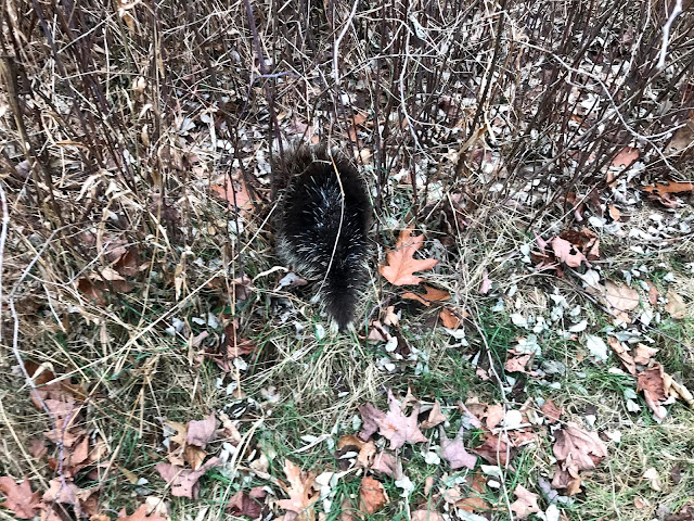
We made our way back the 1.6 miles to the meadow.  Almost across the meadow  we saw!

.


How crazy is that?  In the same spot as we saw him or her last time.  Well not very crazy because they only wander ????   I have no idea.

We searched the Google only to find that they stay close to their den. 

Adults have a range, depending on food availability of six to fourteen acres.


They don't have blue eyes that is the camera on- auto triggering a flash.

This one is about he size of my shoe.  So baby Porky.

 Adult Porkies have 30,000 quills. The quills if stuck in you, travel about an inch a day through your body.  If not pulled out the quill will eventually hit an internal organ or do some other serious damage.

If you don't die form the infection first.

By the way they cannot throw or shoot quills.  You touch you get.


We headed back up the trail towards the Wheeler Farm.  Good day knowing that baby Porky is living the good Porky life..


Monday, November 18, 2019

Mohawk Trail State Forest and another "Cave"

We decided to try and find a cave that we used to snowshoe to many winters ago.  It is not really a cave at all. It is a Huge rock slab that slid off from a much larger rock formation and formed a room.

To get there we took the Mahican Mohawk trail towards upper meadow.


The trail in park is part of the original trail that natives used to travel through this area. Or at least that is what the trails creators think.  I wonder about some of the current route and reasoning behind the location.  But that is for another blog post. 

Upper meadow is a great place and very impressive.  Lower meadow is just as expansive. They were both part of the Wheeler farm. We will do some further investigating to find out about Mr Wheelers neighbors the Jackson family. We heard from the ranger that those were the two farms that made up this area. Tough place to live in the late 1700's


Well it didn't take us long to find our objective:


Rough location-   Nope no UTM!  Put your detective hat on.


We had a quick lunch and noticed the clouds pouring in. Felt like snow was on the way.


As you can see the rocks are quite large in this area


We headed down to the river and through the red pine forest. 


As we walked along we heard a screech from some kind of bird.  We thought it was a hawk or owl. It called out twice with quite long and strange calls.  

We the saw this and saw an eagle flying up through the trees.


It was a baby porky!   Slowly making and escape.


Then Theresa saw this under an old apple tree.


Did junior fall out of the tree?  Once we got home we googled eagles and porkies. Yup an eagle will attack a porky. With often deadly results ( for the eagle). Porky quills harbor lots of nasty bacteria.


Well maybe that is what happened. We will return in a few days to see if junior had injuries from the eagle.  He might have succumbed to them and not have gone far.  Stay tuned.

On the way out I spotted and odd rock by the river. Obviously man-made.


No idea what that was all about.  More mysteries to solve.

We headed down towards the river in hope of connecting to an old road I remembered.  You can see the roads at the tip of the area  in the photo below.  Basically we wanted follow the river back up to the houses in the white area- the ranger station.  We were at the intersection of the rivers near the 210 mark.


We found the old dump. Lots of booze bottles!


We tried but could not make it through that section.  We asked the ranger if the roads did connect at one time and he said yes.We encountered a landslide that wiped out the road and caused a huge slide into the river. Hurricane Irene was the cause of that damage. We had snowshoed that road years prior to that.  Oh well.

Next time we will investigate the Jackson farm. 


Quabbib StarFire and Indian Kitchen

Back to Quabbin today and a visit to a military jet crash site.  We left from gate 40 and hiked the two miles into the crash site.  You can read a complete detailed account of the crash here:

https://www.newenglandaviationhistory.com/tag/f-94-crash-site-quabbin-reservoir/

It is a pretty interesting place to visit and quite amazing that so much wreckage is still in good shape. Yes crunched up for sure. It is a crime to remove anything from the site, so that along with the fact that the plane was made of aluminum, means that there is a good amount of wreckage to check out.


We spent some time there and then headed off to the third piece of the Quabbin trifecta - Indian Kitchen.

Of course it was not made by Indians and is not a kitchen.  It is a huge cave like structure that is the result of our ever present freeze thaw cycles.  Karl and I have done some sleuthing and we had a guess as to where it is located. We read that there might be faint orange blazes leading up to the area. The rough location is the Northeast corner of Pottapaug Hill.


Sorry no UTM's   I have not seen the coordinates published so I will keep them secret for now. I am guessing people like the challenge of finding the spot!

Well we found a couple of faint orange blazes and a very faint trail. The trail headed uphill about sooner than we thought it should. We really thought the kitchen was around the first P in Pottapaug on the map.  After some wandering we found it.


As you can see the room is quite large and is a good place to find shelter if you needed it.  We decided to cook lunch and found an interesting stone bench close by and in the sun. 


I am guessing a hunter probably constructed it.

After lunch we hiked back down to Dana town common and poked around a little.


Someone had a bad day......


Back at the car. Another fine day of wandering.


Monday, November 11, 2019

Indian Bowl- Woburn

Who knew there would be an interesting hike right in my grandsons backyard.  Well close to his house anyways.

 We took advantage of a day that school was closed, to explore the area around Horn Pond and find the elusive "Indian Bowl".  Which as not made by Indians nor a bowl!


We started by having my grandson hand draw a map, based on a map we found online.  It is great practice and really helps with navigation to do that kind of exercise.


Map in hand off we went with my grandson in the lead!


A cool paper wasp nest


How the bowl was actually formed


At least we will not go hungry.   Maybe


Yes batman that is beantown !


Yes we found the bowl!