Thursday, January 28, 2021
Tuesday, January 26, 2021
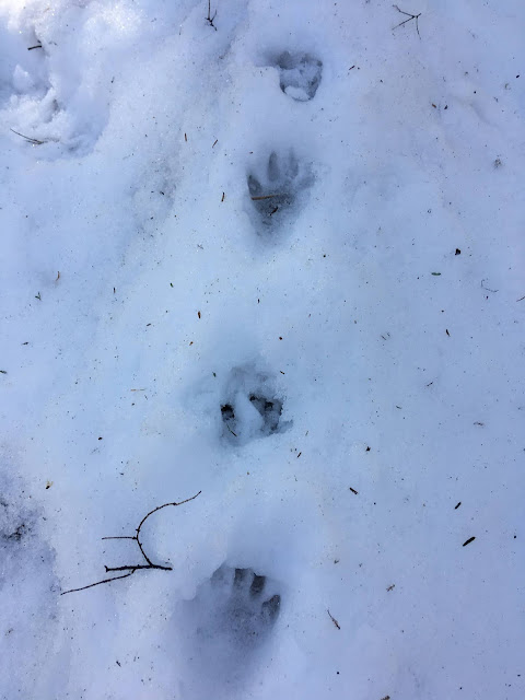
Time to track
Although we have had an almost snowless winter, it is still a good time to get out and scout for tracks. The fact that the snow we have had for the most part was light, creates ideal tracking conditions when it does snow.
Otter Scat


Tuesday, November 3, 2020
The Appalachian Trail Rangeley Maine
Last week Karl, Theresa, and I spent a chilly, but nice weekend car camping on the shore of West Richardson Pond.
We had a chance Saturday to hike to Piazza Rock
Great hike and fun weekend!


Ethel Pond

Bark Directions

Exploring the Caves

Signs at the Shelter Area

Nursery Stump
All Photos by Karl.
Thursday, March 26, 2020
To Puppyville and Beyond
Puppys do not practice any known form of Social Distancing. Yes someday, if this Blog somehow survives, someone will have to reference the InterWeb to decoded that sentence.
Let's tackle the matter of Puppys first. This hike would take us from Gate 27 down to the road that Puppyville was located on.


J.R. Greene recounts a valley resident as saying "Puppyville and Millville should have switched names". Because when they knew the villages Puppyville had no dogs and Millville had no mill. Puppyville at ,one time, did have a resident that had a lot of puppys. Thus the name. Turners Falls has a hill Rabbit Hill, the road up the hill winds up a hill past several houses. Locals on the hill were said to have raised large families.
Off we went to find a lunch spot. Prioritization is a great skill to have when in the woods.

Certainly felt like Spring was coming. So light the stove and lets get lunch going!

Quabbin is such a great habitat for all kinds of species. Woodpeckers or maybe just a solo woodpecker, had quite the trough chiseled out of this tree.

Theresa spotted something down the road. Moose! ( sorry no picture).

We watched it wander into, what we thought were the woods, to the left towards the water. It must have heard or smelled us and moved away at walk.
My sister in-law Mary spotted the first track. The Moose had headed down the road. Moose walking cover territory quickly. Their long legs give them an amazing all-terrain capability.

We wandered to the intersection and down to the waters edge our destination.


Wandering the shore we found this interesting root structure. The was a similar toppled over tree during one of our last adventures here.
Forest Forensics once again.

The trunk of the fallen tree was a pretty significant food source. Unlike the other fallen tree we found there was no growth that looked active to my untrained eye.

Back we go. With Puppyville in the rearview mirror. All along the Quabbin the shoreline views are great.

What have we here? Dinner? Have to put our prepper hats on in these times.

ShagBark Hickory. https://en.wikipedia.org/wiki/Carya_ovata

A whole row of them along the stonewall on the side of the road.
Another day of fine social distancing indeed.
Bob C
Thursday, March 19, 2020
Historic Hikes of the Quabbin
We are tackling a number of hikes outlines in J.R. Greene's book Historic Quabbin Hikes.
The hike today started at Gate 30 and proceeded down the peninsula and looped back up to our starting point just west of the area shown on the map.

We stumbled across the numerous cellar holes listed and some other interesting finds:

We did a little sleuthing and determined Mr or Miss Bear was rooting around for a spring snack. The bee's nest appears to have come from this tree.

We wandered along stopping at various scenic viewpoints. Our lunch stop featured several bald eagles circling, diving for fish, and just being eagles having fun. The day was glorious.

During our travels we came across and interesting tree. The Hawthorn tree.
We will have to return to check out the fruit of this tree.
https://en.wikipedia.org/wiki/Crataegus

You can see where the torn part of the name comes from.

Those would hurt. Survivalists use the thorns to fashion fish hooks.

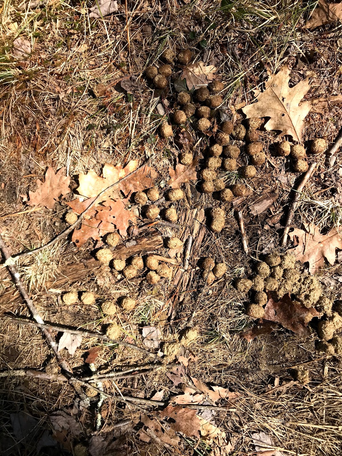
Our friend the Coyote is wandering the area. The scat left behind carries all kind of interesting clues. Here we see undigested bone fragments and hair. Hair and small bone pieces are pretty common finds. This piece was quite large.

Of course everyone was not having the best of days. This Shrew was not napping.

Larger mammals were evidenced as well. Mr or Miss Moose is wandering the quabbin.
The mosses were announcing spring with tiny blooms.

This is an interesting forest forensics exercise.
Trees often fall and the fallen tree supports new vertical growth. The crazy thing about this tree is that two different species of trees sprouted from the same fallen trunk.


This was a very large scat. Wolves were hunted to extinction in this area. This is a big coyote for sure.

All in all a great day of adventuring and discovery.

We ended back at Gate 30 with it's keystone bridge.

On to the next adventure.
Thursday, February 27, 2020
The Boat House - That was Easy- Not!
Theresa and I set off recently with my friend Karl to explore and old boathouse at the Quabbin. We had found this in 2008 and it looked like this at that point in time:

So off we went armed the a map and the UTM of the location.

Should be a piece of cake for two Search and Rescue guys! I remember it being right on the shore. We hiked along a couple of roads and headed down to the shore. Took a left and started looking for the structure. On we went looking around every corner until we were at the powerline ! What ??

How could we have missed it? Wrong UTM? That didn't seem likely but what the heck let's wander back up to the end of the cove. It was a glorious day after all and the frozen reservoir was booming and groaning. Along the way Karl snapped great pictures of stumps, which were submerged many years ago and have now surfaced and drifted into little areas where eddies exist.


All around us was very cool driftwood.

Karl takes great pictures without a doubt.
Well we reached the end of the cove and still no boathouse! The lost-boys conferred.

It didn't just disappear. Or did it?
We entered the Lat/ Long and double checked our UTM and the description from the Geocaching site we had used in 2008 to find it. The site said the cache had been removed. We shot and azimuth and low and behold found a small area along the shore were it had been. DCR must have removed the decaying structure at some point. Mystery solved. We headed off to find a lunch spot.

Ah nothing like a sunny spot for lunch. We broke out the WhisperLite and cooked some grub.

After that we finished the hike in the usual fashion. A good old bushwack using a combination of terrain association, dead reckoning, and compass skills. A fine day indeed.
Subscribe to:
Posts (Atom)