Sunday, December 8, 2019

Snow!

Snow


Wow the first big snow dump of the season and it is only early December. What will winter bring? The forecast is saying 50 degrees and rain in the next few days so time to get out there now kids! 

Back to the old stomping grounds to find a "cave".  This one is similar to Indian Kitchen in the Quabbin.  Both are big slabs that have fractured off of larger sections to form large rooms.  We have been there before and wanted to take our friend Karl along to show him the cave and the area. 

We headed off into the snow the temp was 6 degrees Fahrenheit. 


This area is home to lots of critters. Deer tracks are everywhere and we came across bear tracks crisscrossing various areas. They have a distinctive lumbering gait signature. Claws were visible in some tracks. The bear tracks were a day or so old.  They are still roaming around and looking to that last bit of nourishment prior to deep winter.


Of course winter hikers burn through lots of calories and one of the joys of snowshoeing is that you get to eat a lot of good food.

"According to an independent study conducted by the University of Vermont, snowshoers can burn 420-1000 calories per hour. “Snowshoeing is an effective, low impact, and safe form of exercise to change body composition"


Karl was trying out his new stove. We both rock MSR stoves. They are like jet engines and really throw lots of heat. No simmer possible just hardcore BTUs.   That is what you need when it is below 20F out.


Tasty treats abound!


 We finished lunch and headed back bushwhacking through the woods.


Almost to the top we intersected the road. Once on the road we met a lone skier heading downhill.  He was perhaps in his late 70's and accompanied by his dog Thelma.  We chatted for a while and he had a keen interest in where we had been, being curious and wanting to explore new areas. We drew him a snow map which Thelma proceeded to run through.  We told him to follow our tracks once he was in the upper field and not to follow our uphill slog to the road. It was really steep in some places.

 He commented that he felt the need to get out and experience the snow cover as global warming was certainly affecting the amount and quality of snowfall. He said who knows it could be the last time he sees this quality of skiing snow.  Sobering but true.  


As I bushwhacked off the road once again I couldn't help but feel sad for future generations and sad for the current human population.  The old man said they have the most wonderful experience in the world fed to them through their cell phones. Why go outside? 

 We pondered that and relished the fact that we had actually seem another human being outside- in the woods- in the winter- enjoying themselves. Crazy right. 

Who in their right mind goes outside when you could sit on the couch and watch the world go by via your digital crack pipe?


 On the way home Karl commented that those Direct TV satellite dishes look like hungry birds waiting for Momma bird to shovel some more crap down their digital throats. 

Yum Yum Kids Enjoy!


Get outside!

 https://www.rei.com/opt-outside

Oak Hill Washington, N.H.

We had a chance to head up to our friends house in Washington NH  and stretch our legs prior to what would prove to be a major snow dump at our house. It was a quick visit and we wanted to catch a quick hike in the area.

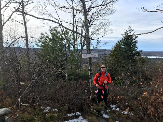
Oak hill is a small peak along the Monadnock Sunapee Greenway which runs through the town of Washington.


Interestingly the top of the mountain actually has some Oak trees. Yes this is unusual as hardwoods have been logged in the area since the 1700's. 

The top of the mountain is in a regrowth phase with evidence of logging everywhere. In this area, small pines and firs sprout up quickly and provide super dense bird cover and winter browse for moose. 

Ice was in full bloom along the trail as we climbed.


Many trail egresses in the area are the result of partnerships with private landowners. This section of the trail crossed private property in many sections. These partnerships are amazing and of course fragile. If you hike areas such as these, stay on the trail, leave the place better than you found it, and thank the landowner if you see them!  More about the Greenway can be found here:


As we hiked along we really started to notice some really interesting things like this pattern of woodpecker holes running up a tree. 


Guessing this type of woodpecker may be the one responsible. But who knows!


We bombed along taking in the sights and before we knew it we were at the top!


Yup conquered that 1900 footer!

All in all good time visiting friends sharing food, stories, and hiking.


Mt Toby

Mt Toby is a great location to hike during hunting season which on upon us!


By the way telephone trail is not the easiest way up in my opinion. The fireroad is. Telephone is quite eroded and steep in sections.


Lots of history here. Like many of the valley peaks it had a hotel on the top at one time.  Here is the blurb from Wikipedia:

Mount Toby is named for Captain Elnathan Toby, a settler from colonial Springfield, said[who?] to be the first Caucasian to summit the mountain. Like other peaks in the Connecticut River Valley in the 18th century, a resort hotel was built on the summit of Mount Toby, but it burned down a year after it was constructed, and was not rebuilt. The land was subsequently acquired by the Massachusetts Agricultural College (now the University of Massachusetts Amherst), and is currently part of the Mount Toby State Demonstration Forest owned and managed by the University.[3]

We frequent the area and have covered lots of trails. Trail maps are not available at the trailhead.  The best one out there is this PDF version:

The best route in this season is up the fire road to the top. It is a nice walk up along the river, forming basically a safety corridor during hunting season. Give hunters lots of room to work and hikers a nice path to the top. 


Winter was making itself known early this year depositing a layer of frost in the higher elevations.


At the top you can always climb the fire tower for  good view of Monadnock region to the north and Sunderland to the south. Greylock is visible on a clear day. 


We were pressed for time so we headed on down.  Toby is a nice hike that will take you 2- 21/2 hours round trip using this route.  Check it out if your in the area.